|
Pot Spring
 311 Timber River Rd., Lee, FL 32059 311 Timber River Rd., Lee, FL 32059
|
Max Depth: 81-90ft/25-27m
Average Viz: 51-60ft/16-18m
Entry Type: Shore
Bottom Composition: Clay/Muck
Aquatic Life: Might See Something
|
Spring: 71-75°F/22-24°C
Summer: 71-75°F/22-24°C
Fall: 71-75°F/22-24°C
Winter: 71-75°F/22-24°C
|
|


|
|
Portions of the following information were taken from Florida Geological Survey Bulletin 66.
Pot Spring is located approximately 1.3 miles south of the SR 6 bridge over the Withlacoochee River. It is also accessible via land by following the signs just east of the SR 6 bridge.
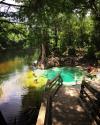
Description - Pot Spring was not flowing during the November 2002 visit and the spring pool was filled by the tannic Withlacoochee River. The pool is oval shaped, measuring 30 ft northeast to southwest by 22 ft northwest to southeast. Depth measures 14 ft. When the spring is flowing, the water is clear and bluish-green. A wooden platform borders the southeast section of the pool. On the northeast side, stairs lead from the spring up to a picnic area and parking lot. SRWMD land surrounds the pool and rises to 15 ft above the water surface. Vegetation on the sides of the pool is sparse and includes grasses, palmettos, and cypress trees. The spring is used as a local swimming hole. Discharge on June 15, 1998 measured 38.19 ft3/s.